

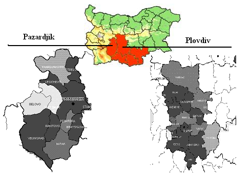
Pazardjik and Plovdiv
The research will further focused on the both districts (NUTS 3 level) – Pazardjik (contains 11 municipalities with a territory of 4457 sq.km.) and Plovdiv (contains 18 municipalities and comprises 5973 sq.km. of territory) which are part of the South Central planning region (Figure 1).
Figure 1. Map of the Pazardjik and Plovdiv - region for scenario development
The territory of the two districts contains roughly 10% of Bulgaria’s territory and 984210 residents (13.1% of country population, National Statistical Institute 2010).
The region has a varied landscape with mountainous and semi-mountainous areas river valleys and lowlands. The climate, with well-defined seasons, is of a Mediterranean type, with the exception of the mountainous parts.
Both of the districts are well-developed agricultural and industrial regions. On an average the agricultural land in the region amounts to 48% of the total land in Pazardjik and Plovdiv districts. The soils are among the most fertile in the country, suitable for growing of cereal, industrial crops, vegetables and vineyards. In 2010, the total number of agricultural holdings in both districts is 52 thousand or 14% out of the total number of agricultural holdings in Bulgaria. (Ministry of Agriculture and Food, Agricultural Census 2011).
A Major characteristic of the districts’ economy is its diversification and the existence of traditional production methods. The main sectors which characterise the local economy are: food production, beverages and tobacco, metallurgy and manufacturing of metal products; textile and clothing, paper and paperboard production, fibers and products, production of machinery and equipment manufacturing. The sectors of agriculture and industry provides 5.6% and 40.8% respectively in the total amount of GVA for the two districts while the service sector provides 53.6%. The average unemployment rate for the region is around 12% as it is higher in the district of Pazardjik. (National Statistical Institute data, 2010).The territory is important because the road from Western Europe to Istanbul crosses, as well as the Trakia highway connecting South-Western Bulgaria with the Black Sea coast and the route connecting Northern and Southern Bulgaria.
According to the OECD definition (applicable for NUTS 3 level - districts), Pazardjik is classified as a predominantly rural region and Plovdiv as an intermediate rural region. According to the national definition (applied in the RDP 2007-2013 for territorially based interventions in Bulgaria), rural areas are municipalities (applicable for LAU1 level - municipalities), in which no settlement has a population over 30000 people and population density is under 150 inhabitants per sq.km. According to this definition, 26 municipalities in the region are classified as rural. The three municipalities – Pazardjik, Plvodiv and Asenovgrad (part of Plovdvi district) – has a main town with population over 30000 people and at the same time they are well connected with the other settlements which make commuting for employment possible. The peri-urban pressures occur mainly around the Plovdiv (the largest city in the region).